Revised airport-area proposal narrows scope
The City of Brantford and the County of Brant have released an updated concept for a potential boundary adjustment surrounding the Brantford Municipal Airport, scaling back the proposed transfer area and setting new opportunities for public input later this month.
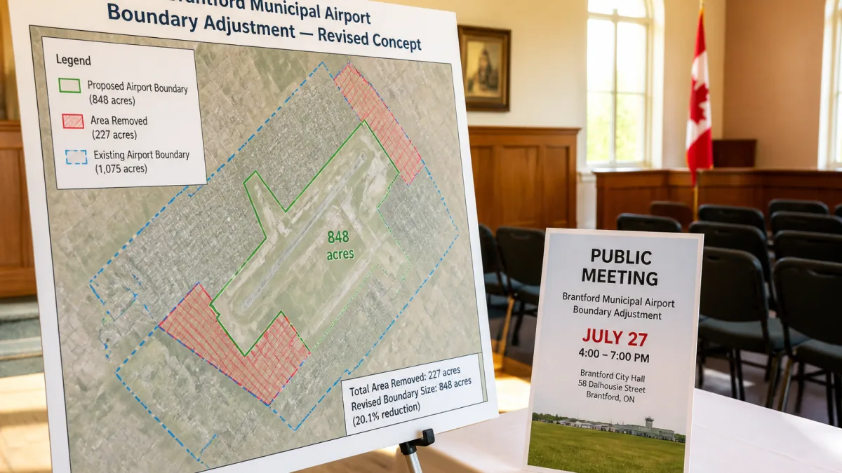
According to a joint update issued on July 13, 2026, the municipalities have removed 469 acres — including portions of agricultural land — from the originally identified area. The revised concept would now place 848 acres of land near the airport under the City of Brantford’s jurisdiction, should an agreement proceed.
In a joint statement, officials said the change was made as a “direct response to public feedback.”
Boundary adjustments are inter-municipal agreements that shift jurisdictional lines to realign responsibility for planning, taxation and delivery of services. The latest map, published by both municipalities, shows a tighter footprint around the airport than earlier iterations. Residents are being asked to review the updated map and offer comments before any further steps are considered.
How to participate and when to attend
Members of the public can view the revised concept and submit feedback through the City’s Let’s Talk Brantford platform. Two statutory public meetings are planned to gather additional input. More information about how to participate will be released closer to the dates, according to the municipalities.
| Meeting | Date & Time | Location |
|---|---|---|
| City of Brantford statutory meeting | Monday, July 27, 6 p.m. | Brantford City Hall, Dalhousie Street |
| County of Brant statutory meeting | Monday, July 27, 6 p.m. | County of Brant Council Chambers, Broadway Street, Paris |
Officials say they will communicate participation details ahead of the sessions, which are designed to meet statutory requirements for receiving public input on boundary adjustments.
What the change could mean locally
Moving land from county to city jurisdiction typically affects how property is planned and serviced, including the application of city bylaws, zoning, taxation, and long-term infrastructure planning. While specific development proposals were not outlined in the update, the area in question sits around the Brantford Municipal Airport, a regional general-aviation hub. Any boundary change would later require detailed planning work to align policies and services in the transferred area.
By trimming the footprint to 848 acres, the municipalities indicate they have attempted to respond to issues raised by residents, including concerns about agricultural properties. The joint statement notes that the revised concept reflects feedback gathered to date, and invites further comment before decisions are finalized.
Next steps in the process
Boundary adjustments typically involve negotiation between municipalities, public consultation, and formal approvals by councils. If the concept advances after the July meetings, additional reports and agreements would be required. The municipalities have not provided a timeline for a final decision.
- Review the updated map on the City’s Let’s Talk Brantford site.
- Attend a statutory meeting on July 27 at 6 p.m. in Brantford or Paris.
- Watch for further instructions on how to participate, to be posted by the municipalities.
Residents can continue to follow municipal updates for documents, maps and participation details as the proposal moves through consultation.